Dolpo to Mugu Trek via GHT (Great Himalayan Trail)

Trip Facts

Duration:
30 days
Trekking Region:
Dolpo Region
Max. altitude:
5,563 m / 18,252 ft
Grading:
Strenuous
Best Time:
September - November / April - May
Group size:
2-10 pax
Accomodation:
Full Camping
Meals:
Breakfast, lunch, and Dinner
Trasportation:
Flight and Private vehicles

Trip Highlights

  • Trek a major section of the Great Himalayan Trail through far-western Nepal
  • Cross five high passes, including Nyingma Gyanzen La, the highest point on the route
  • Visit Phoksundo Lake, one of Nepal's deepest and most scenic high-altitude lakes
  • Explore Shey Gompa and the Crystal Mountain in the heart of Upper Dolpo
  • Follow the Mugu Karnali River valley through remote high-altitude terrain
  • Camp at Rara Lake, the largest lake in Nepal, within Rara National Park
  • Observe Himalayan wildlife, including blue sheep, Himalayan tahr, and snow leopards
  • Experience living Bon and Tibetan Buddhist culture in restricted-area villages
  • Fly in and out of remote mountain airstrips at Juphal and Talcha

Trip Overview

The Dolpo to Mugu trek via the Great Himalayan Trail (GHT) is one of the most remote and demanding high-altitude routes in Nepal. Crossing five major passes above 5,000 meters, this trek connects the restricted regions of Dolpo and Mugu through a fully wilderness route along Nepal's northern border with Tibet.

The journey begins at Juphal Airport in Dolpa District and ends at Talcha Airport in Mugu District. Along the way, trekkers pass through Phoksundo Lake, Shey Gompa, the isolated villages of Bhijer and Pho, the Mugu Karnali Valley, and Rara Lake (Nepal's largest lake). The entire route is 100% camping; there are no teahouses or lodges on the high section. 

This trek is designed for experienced, physically prepared trekkers seeking genuine wilderness immersion in far-western Nepal. The Dolpo to Mugu trek is ideal for trekkers looking for a remote Himalayan expedition far from Nepal’s crowded trekking trails.

Trek Overview

The Dolpo to Mugu trek via the Great Himalayan Trail traverses one of the most remote trekking corridors in the Himalayan range, connecting two restricted districts of far-western Nepal in a continuous wilderness crossing. Starting at Juphal Airport in Dolpa and ending at Talcha Airport in Mugu, the route follows the Tibetan border through its northern section and ranks among the most demanding segments of the Great Himalayan Trail Nepal network.

From Juphal, the trail passes through Dunai to Phoksundo Lake, crosses Kang La (5,350m) into Upper Dolpo, and continues north through Shey Gompa and the villages of Bhijer and Pho. The route circumnavigates the Kanjiroba massif via four further high passes, Yambur La (4,813m), Nyingma Gyanzen La (5,563m), Yala La (5,414m), and Chyargo La (5,150m), before descending the Mugu Karnali Valley to finish at Rara Lake and Talcha Airport.

Fully camping-supported with no lodge infrastructure between Phoksundo Lake and Gamgadhi, the trek requires a licensed guide and six restricted area permits. It suits experienced high-altitude trekkers with strong fitness and prior expedition camping experience.

Why Choose the Dolpo to Mugu GHT Trek?

The Dolpo to Mugu GHT trek is the only route in Nepal that connects two major restricted-area regions in a single continuous wilderness crossing. It combines two iconic high-altitude lakes, Phoksundo Lake and Rara Lake, with five passes above 5,000 meters, ancient Bon-Buddhist heritage, and landscapes that see fewer than 150 trekkers per year. 

No other route in Nepal offers this combination of geographic scope, cultural depth, and true remoteness in one itinerary. This is a true off-the-beaten-path trekking Nepal experience through isolated valleys, ancient villages, and untouched Himalayan landscapes.

For trekkers seeking a step beyond the standard Nepal circuit, this route delivers conditions and experiences that established trails cannot replicate. The remoteness of the high route demands full self-sufficiency and professional logistical support, both of which Dolpo Caravan Treks specializes in. The quality and exclusivity of the experience directly reflect the investment in permits, logistics, and a qualified team.

Need help choosing the right itinerary for this remote Himalayan route? Our trekking specialists can help you understand the route, difficulty, permits, and best season before you book.
Itinerary Overview

This Dolpo to Mugu trekking itinerary includes acclimatization days, remote camping sections, and gradual altitude gain for safer trekking.

Detail Itinerary

Arrive at Tribhuvan International Airport and transfer to your hotel. Your guide will conduct a pre-trek briefing covering the route, permits, gear, and logistics. Rest and rehydrate.

  • Travel distance: Tribhuvan International Airport to hotel ~6-8 km 
  • Travel type: Private Vehicle 
  • Meals: Dinner (Depending upon arrival time)
  • Accommodation: Hotel in Kathmandu

Early flight to Nepalgunj, then onward by Twin Otter to Juphal Airport. The mountain approach is dramatic, threading through narrow ridgelines before landing. The trek crew meets you at the airstrip. Flights operate mornings only, weather permitting.

  • Travel Distance: Kathmandu to Nepalgunj ~365 km (by air) | nepalgunj to Juphal ~145 km 
  • Travel Type: Domestic Flight + Private Transfer
  • Meals: Breakfast, Lunch, Dinner
  • Accommodation: Hotel

Descend toward the Bheri River valley, cross the Thulo Bheri suspension bridge, and follow the riverbank to Dunai, Dolpa's district headquarters. A straightforward warm-up day.

  • Travel distance: 10 km - 12 km 
  • Travel type: Trek
  • Meals: Breakfast, Lunch, Dinner
  • Accommodation: Camping

After completing Shey Phoksundo National Park permit formalities, the trail crosses the Suli Gad River and ascends the Suli Gad Valley through pine and juniper forest, crossing several suspension bridges as the river narrows. Chhepka is a small settlement above the gorge, marking the real beginning of the Phoksundo approach.

  • Travel distance: 16 km - 18 km  
  • Travel type: Trek
  • Meals: Breakfast, Lunch, Dinner
  • Accommodation: Camping

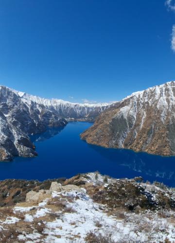
The trail climbs higher into the Suli Gad gorge, passing a large waterfall that drops directly across the path. Above the falls, the valley opens and the landscape shifts from dense forest to open rock. Phoksundo Lake appears abruptly, a vast expanse of deep turquoise water enclosed by sheer limestone cliffs. The small Bon village of Ringmo sits at the lake's southern edge. Camp near Ringmo.

  • Travel distance: 13 km - 15 km 
  • Travel type: Trek
  • Meals: Breakfast, Lunch, Dinner
  • Accommodation: Camping

Rest day at Nepal's second deepest lake (145m). Visit the Bon monastery Tshering Choling Gompa in Ringmo and hike above the village for elevated lake views. Monitor altitude symptoms carefully, passes ahead exceed 5,000 m.

  • Travel distance: 4-6 km (round-trip hike) 
  • Travel type: Hike 
  • Meals: Breakfast, Lunch, Dinner
  • Accommodation: Camping

Departing Ringmo, the trail cuts along the western shoreline of Phoksundo Lake on a narrow path carved into the cliff face. At the northern end of the lake, the path enters the Phoksundo Khola valley and begins climbing along the river headwaters. Camp is set on a flat riverside site below the approach to Kang La. This is the last reliable water source before the pass. The night will be cold.

  • Travel distance: 10 km - 12 km 
  • Travel type: Trek
  • Meals: Breakfast, Lunch, Dinner
  • Accommodation: Camping

An early alpine start. The ascent to Kang La is steep and sustained on loose scree and rock. At the summit, the full sweep of the Kanjiroba Himal comes into view, a chain of peaks above 6,000 m virtually unknown outside Nepal. The descent drops through a dry rocky gorge into the open plateau of Upper Dolpo. The whitewashed walls and gilded rooftop of Shey Gompa appear beneath the unmistakable pyramid of Crystal Mountain. Camp near the monastery.

  • Travel distance: 14 km - 16 km 
  • Travel type: Trek
  • Meals: Breakfast, Lunch, Dinner
  • Accommodation: Camping

Shey Gompa is one of the oldest and most venerated monasteries in Dolpo, believed to have been founded in the 10th century. Visit the main gompa and the Tsakang cliff hermitage. Walk the sacred Crystal Mountain circumambulation trail, one of the most important pilgrimage routes in Upper Dolpo. This rest day also allows for further acclimatization before the remote northern section begins.

  • Travel distance: 4 - 5 km local walk
  • Travel type: Short hike 
  • Meals: Breakfast, Lunch, Dinner
  • Accommodation: Camping

The trail leaves Shey heading north and west across open plateau country. The trail is less defined on this section; your guide navigates by terrain features rather than a clear path. Blue sheep (bharal) are commonly spotted on the surrounding hillsides. Tora is a seasonal grazing area used by herders from surrounding villages in the summer months. Camp on the plateau. 

  • Travel distance: 12 km - 14 km 
  • Travel type: Trek
  • Meals: Breakfast, Lunch, Dinner
  • Accommodation: Camping

The terrain becomes increasingly arid as the landscape pushes toward Tibetan Plateau characteristics. The trail passes through barren valleys and over minor ridges before reaching Samling. The Samling Gompa is one of the most important centers of Bon culture in Dolpo, estimated to be around 900 years old, with ancient murals and a resident lama community.

  • Travel distance: 10 km - 12 km 
  • Travel type: Trek
  • Meals: Breakfast, Lunch, Dinner
  • Accommodation: Camping

The trail descends through ridges and open valleys toward Bhijer, one of the lowest and most fertile villages in Dolpo. Wheat and apricot trees grow here, a rarity at this elevation. The village has a small monastery and a traditional Amchi (Tibetan medicine) clinic. Bhijer is the last settlement with any infrastructure before the route's most remote section. Rest and eat well, as the next few days will demand it.

  • Travel distance: 11 km - 13 km 
  • Travel type: Trek
  • Meals: Breakfast, Lunch, Dinner
  • Accommodation: Camping

Mandatory logistics day. Loads reorganized, food supplies verified, equipment checked. Guide briefs the team on passes, campsites, and emergency protocols. No resupply points exist between here and the Mugu Karnali Valley.

  • Travel distance: 2 - 3 km local walk 
  • Travel type: Short hike 
  • Meals: Breakfast, Lunch, Dinner
  • Accommodation: Camping

The trek enters its most remote phase. The trail climbs out of Bhijer into a long uninhabited valley running parallel to the Tibetan border. Pho Village, also known as Phowara, is one of Nepal's most isolated inhabited places, where a small number of families maintain traditional dress, customs, and a Tibetan dialect largely unchanged by outside contact.

  • Travel distance: 15 km - 17 km  
  • Travel type: Trek
  • Meals: Breakfast, Lunch, Dinner
  • Accommodation: Camping

The valley narrows as the trail climbs toward Yambur La, following a river upstream through a steep-walled gorge with multiple crossings. Some sections are carved directly into the rock face, narrow and exposed, requiring care. Camp on a high-altitude flat below the pass with wide views back down the valley.

  • Travel distance: 9 km - 11 km 
  • Travel type: Trek
  • Meals: Breakfast, Lunch, Dinner
  • Accommodation: Camping

Early start for the second major pass. The ascent is steep but shorter than Kang La. From the summit, the glaciated northern face of the Kanjiroba massif stretches across the horizon. The descent drops steeply into a narrow gorge before opening into a wider valley. The route now arcs around the Kanjiroba's northern flank through terrain almost no trekker visits.

  • Travel distance: 12 km - 14 km 
  • Travel type: Trek
  • Meals: Breakfast, Lunch, Dinner
  • Accommodation: Camping

A sustained ascent through high-altitude pastureland past seasonal yak herder shelters, known as "kharkas." The surrounding landscape is vast and without reference points, with ridgeline after ridgeline above 5,000 m. Camp early at the highest overnight site on the route. Temperature drops sharply after sunset.

  • Travel distance: 10 km - 12 km 
  • Travel type: Trek
  • Meals: Breakfast, Lunch, Dinner
  • Accommodation: Camping

The summit of the entire trek. Depart before dawn on a mixed terrain of scree, rock, and spring snow. At 5,563 meters, this peak is the highest point on the Dolpo to Mugu Great Himalaya Trail route and one of the highest regularly crossed passes in western Nepal. The summit panorama spans an enormous arc of the Trans-Himalayan range, north into Tibet and the Kanjiroba south. The descent is long on steep, loose ground, and careful footwork is required. Camp in the valley below.

  • Travel distance: 13 km - 15 km 
  • Travel type: Trek
  • Meals: Breakfast, Lunch, Dinner
  • Accommodation: Camping

Mandatory full rest after the highest crossing. Hydrate, eat well, and limit exertion. The guide monitors oxygen saturation. Two passes remain, and adequate recovery here directly affects performance on both.

  • Travel distance: 2 km - 3 km 
  • Travel type: Short hike 
  • Meals: Breakfast, Lunch, Dinner
  • Accommodation: Camping

The route continues westward along the high valley system on the northern face of the Kanjiroba range, an open tundra interrupted by steep lateral ridges. As the valley trends west, slightly more vegetation appears on south-facing slopes. Camp at the base of Yala La, with the pass clearly visible above.

  • Travel distance: 11 km - 13 km 
  • Travel type: Trek
  • Meals: Breakfast, Lunch, Dinner
  • Accommodation: Camping

The fourth major pass was approached on a moderately graded slope compared to previous crossings, though altitude demands continued respect. From the summit, the route begins its long arc south and west toward Mugu District. The descent leads into the upper Mugu Karnali drainage, with slightly greener terrain as altitude drops.

  • Travel distance: 14 km - 16 km 
  • Travel type: Trek
  • Meals: Breakfast, Lunch, Dinner
  • Accommodation: Camping

The fifth and final pass is within reach. The trail climbs steadily through open high-altitude terrain, crossing seasonal streams and boulder fields. The stark northern landscape gradually gives way to broader, less severe terrain. Camp below Chyargo La with clear views of the pass above.

  • Travel distance: 10 km - 12 km 
  • Travel type: Trek
  • Meals: Breakfast, Lunch, Dinner
  • Accommodation: Camping

The final major pass of the GHT high route. The ascent is sustained and demanding, but the team is now well conditioned. From the summit the route bends decisively south and west. The descent covers over 1,000 vertical meters, from alpine rock through high scrub to the broad Mugu Karnali River valley below. Reaching the valley floor marks the end of the most remote section of the trek.

  • Travel distance: 15 km - 17 km 
  • Travel type: Trek
  • Meals: Breakfast, Lunch, Dinner
  • Accommodation: Camping

Following the Mugu Karnali River downstream, the valley gradually widens and vegetation increases. Juniper, wild roses, and patches of forest appear along the riverbanks. Mugu Village, also known as Khatyar, is the first significant community since Bhijer. Permanent houses, cultivated fields, and domestic animals mark a clear psychological shift after the extended wilderness.

  • Travel distance: 12 km - 14 km 
  • Travel type: Trek
  • Meals: Breakfast, Lunch, Dinner
  • Accommodation: Camping

A long descent of over 1,200 vertical meters through increasingly lush terrain and small farming settlements to Gamgadhi, Mugu's remote district headquarters. The town has a small bazaar, a government hospital, and a police checkpoint for restricted area permit review. The warmth at this altitude is a noticeable contrast to the high-route camps.

  • Travel distance: 18 km - 20 km 
  • Travel type: Trek
  • Meals: Breakfast, Lunch, Dinner
  • Accommodation: Camping

Ascend through rhododendron forests, pine stands, and open meadows into Rara National Park. The park boundary brings a distinct change: dense forest, birdsong, and no grazing pressure. Rara Lake appears from the final ridge. Nepal's largest lake, at 10.8 square kilometers, is a deep cobalt blue set in a bowl of forested hills at 2,990 meters. Camp at the lakeshore.

  • Travel distance: 12 km - 14 km 
  • Travel type: Trek
  • Meals: Breakfast, Lunch, Dinner
  • Accommodation: Camping

A full day in Rara National Park (106 sq km). The lake circuit takes 4-5 hours through rhododendron and pine forest with consistent lake views. Wildlife includes musk deer, Himalayan black bears, leopards, red foxes, and migratory birds on the Central Asian flyway. After weeks of high-altitude wilderness, the warmth, color, and biodiversity of Rara make for a memorable final destination.

  • Travel distance: 4 km - 5 km (Exploring Rara Lake)
  • Travel type: Short hike 
  • Meals: Breakfast, Lunch, Dinner
  • Accommodation: Camping

A short morning trek through the national park to Talcha's grass airstrip. Morning-only flights, weather permitting. The Twin Otter to Nepalgunj takes approximately 50 minutes, descending from the high lake basin to the Terai plains. Transfer to the hotel on arrival.

  • Travel distance: 6 km - 8 km 
  • Travel type: Trek + domestic flight
  • Meals: Breakfast, Lunch, Dinner
  • Accommodation: Hotel in Nepalgunj

Morning flight to Kathmandu. Transfer to hotel. The remainder of the day is free for rest, shopping in Thamel, or a final meal with your guide and team.

  • Travel distance: Nepalgunj to Kathmandu ~365 km (by air)
  • Travel type: Domestic Flights + Private Transfer 
  • Meals: Breakfast & Lunch
  • Accommodation: Hotel in Kathmandu

Reserved in case of flight delays due to mountain weather. If not needed, you can relax, shop, or explore heritage sites.

  • Travel Distance: Local city travel as required
  • Travel Type: Private Vehicle
  • Meals: Breakfast
  • Accommodation: Hotel in kathmandu

Transfer to Tribhuvan International Airport for your international departure, marking the end of your Dolpo to Mugu trek via GHT. 

  • Travel Distance: Hotel to Airport ~6-8 km
  • Travel Type: Private Vehicle
  • Meals: Breakfast (depending on flight time)

Cost Includes

  • Airport transfers (international and domestic, arrival and departure)
  • All domestic flights: Kathmandu-Nepalgunj-Juphal and Talcha-Nepalgunj-Kathmandu
  • All required trekking permits and national park entry fees
  • Hotel accommodation in Kathmandu (2 nights, bed and breakfast, 3-star)
  • Hotel accommodation in Nepalgunj as required for flight connections
  • Full expedition camping setup: sleeping tents, dining tent, kitchen tent, toilet tent
  • All meals during the trek (breakfast, lunch, dinner) and hot beverages
  • Government-licensed senior trekking guide
  • One expert trek leader with a local assistant
  • Experienced high-altitude cook and kitchen staff
  • Porters and/or mule transport for all group equipment
  • First aid kit with basic altitude medication
  • Farewell dinner in Kathmandu.

Cost Excludes

  • Nepal Visa 
  • International flights
  • Personal expenses and meals in Kathmandu.
  • Travel insurance (it's mandatory for rescue and evacuation).
  • Tips and gratitude for staff and guides. 
  • Donation and local entrance fee.
  • Extra baggage weight on domestic flight
  • Personal expenses like alcohol, local fabric, and local monuments.

Useful Information

Dolpo to Mugu Trek Cost

The cost of Dolpo to Mugu trek is higher than a standard Nepal route typically USD 4,500 - 6,000 per person and varies by group size and departure season. This cost is mainly driven by three primary factors:

Permits. Six separate permits are required: the Upper Dolpo Restricted Area Permit, the Lower Dolpo Restricted Area Permit, the Mugu District Permit, the Shey Phoksundo National Park Permit, the Rara National Park Permit, and a TIMS Card. The Upper Dolpo RAP alone costs USD 500 per person for the first 10 days, with additional daily fees of USD 50 per day beyond that.

Transportation & Logistics. There is no road access on the high route between Phoksundo Lake and Gamgadhi. All food, fuel, and equipment must be carried by porters or mules from the start. The supply chain for a 28-32 day expedition in this region requires careful preplanning and a larger support team than standard routes do.

Flights. Twin Otter flights to remote mountain airstrips such as Juphal and Talcha are weather-dependent and priced at a premium. Flight delays are common, and contingency nights in Nepalgunj are a standard part of planning.

The package price covers all logistics, permits, staffing, camping equipment, and full catering for the duration of the trek.

Food & Accommodation

The Dolpo to Mugu GHT trek is a fully supported expedition camping trek. No teahouses, guesthouses, or lodges exist between Phoksundo Lake and Gamgadhi. All accommodation throughout the high route is a tented camp. This fully supported camping trek in the Nepal Himalayas is designed for trekkers seeking remote wilderness instead of teahouse routes.

Accommodation:

♦ Trekking tents include sleeping tents for each person, dining tents, and a kitchen tent.
♦ Sleeping tents usually fit 2 people, with options for solo use if needed. Mats or foam pads are provided to keep you insulated from the cold ground.
♦ Campsites are chosen near water sources or flat areas close to villages when possible. This helps with safety, stability, and access to natural resources.

Meals and Cooking:

♦ Professional trekking cooks prepare meals daily and are experienced with high-altitude cooking.
♦ Breakfast usually includes porridge, eggs, bread, or local options.
♦ Lunch is light but nutritious, often rice, noodles, or vegetables.
♦ Dinner is hearty, with dal (lentils), rice, vegetables, and sometimes meat if available.
♦ Snacks, tea, and hot drinks are served throughout the day to keep energy levels up.

Hotel accommodation is provided in Kathmandu and Nepalgunj. Basic guesthouses are available in Gamgadhi at the end of the route. No other accommodation infrastructure exists on the trek.

Best Time for the Dolpo to Mugu Trek

The best time for the Dolpo to Mugu Trek is during autumn (September to November) and spring (April to May). These months offer stable weather, clearer mountain views, safer high-pass crossings, and better trekking conditions throughout the remote Great Himalayan Trail route. For a broader seasonal overview, you can read our guide about the best time to trek in Dolpo.

Autumn: September to November (Primary Season)

Autumn is the optimal trekking window for this route. The monsoon clears by mid-September, bringing stable weather, excellent visibility, and reliable trail conditions. October offers the most consistent conditions across all five passes. November remains viable, but temperatures at altitude drop significantly by month's end.

Spring: April to May (Secondary Season)

Spring provides clear skies and warmer daytime temperatures at lower elevations. Snow remains on the high passes through April, and early spring crossings carry a higher objective risk. May is generally more reliable for passable conditions on this route.

Winter: December to March

High passes become impassable or carry serious avalanche risk. Temperatures regularly fall below -20°C / -4°F at altitude. The route is not viable for standard trekking groups in winter.

Monsoon: June to August (Not Recommended)

While Dolpo's rain-shadow location reduces rainfall relative to other Nepal regions, trail conditions deteriorate significantly. River crossings become hazardous, and visibility at altitude is unreliable. This season is not suitable for the GHT high route.

dolpo-trekking-nepal.jpg

Permits for Dolpo to Mugu Trek

Six permits are required to complete the Dolpo to Mugu trek via the GHT. Since this is a restricted area trekking route in Nepal, all permits must be arranged through a registered trekking company. Dolpo Caravan Treks manages all permit applications on behalf of trekkers.

Permit Required For Fee
Upper Dolpo Restricted Area Permit (RAP) Access to Upper Dolpo restricted zone, Shey Gompa and all high passes USD 500/person (first 10 days) then USD 50/day
Lower Dolpo Restricted Area Permit Lower Dolpo section between Juphal and the Upper Dolpo boundary USD 20/person for 1st week then USD 5/day
Mugu District Restricted Area Permit Entry into Mugu District USD 100/person for 1st week then USD 15/day
Shey Phoksundo National Park Permit Entry into Shey Phoksundo National Park covering Phoksundo Lake NPR 3,000 (~USD 23–25) per person
Rara National Park Entry Permit Entry into Rara National Park at the trek's conclusion NPR 3,000 (~USD 23–25) per person
TIMS Card Mandatory for all trekking routes in Nepal NPR 2,000 (~USD 15) per person


For updated official trekking permit regulations and restricted-area fees, check the Nepal Immigration Department trekking permit page.

Note: A minimum group size is not required, solo trekkers may obtain individual permits. However, a licensed guide is mandatory under Nepal government regulations. Independent trekking without a guide is not permitted in either restricted area.

Mugu to Dolpo Trek Difficulty & Preparations

The Dolpo to Mugu GHT trek is graded as strenuous to expert. The Dolpo to Mugu trek difficulty level is considered strenuous due to multiple high passes, remote terrain, and long trekking days. It is not appropriate for first-time trekkers or those without prior high-altitude experience. This route is considered one of the toughest forms of high-altitude trekking in Dolpo due to its remote passes and long wilderness sections.

Key difficulty factors:

♦ Trekking days of 6-8 hours, extending to 8-10 hours on pass days
♦ Five passes above 5,000m / 16,404ft, with the highest at 5,563m / 18,252ft
♦ Sustained high-altitude exposure for multiple consecutive weeks
♦ No evacuation infrastructure between Bhijer and Gamgadhi
♦ Night temperatures regularly below -10°C / 14°F at high camps
♦ No lodge or resupply points on the high route, full commitment once departed

Recommended preparation (minimum 1-3 months before departure): Before attempting this expedition, it is helpful to understand the essential trekking preparation for Nepal, especially for remote high-altitude routes.

♦ Cardiovascular training: running, cycling, or stair climbing 4-5 days per week
♦ Weighted backpack hiking on varied terrain
♦ Leg and core strength training
♦ At least one prior multi-day trek above 4,000m / 13,123ft
♦ Physician consultation regarding altitude medication (Diamox)

Need help planning the Dolpo to Mugu GHT trek? Contact Dolpo Caravan Treks for expert advice, trip details, and preparation support.

Dolpo to Mugu Trek Acclimatisation

The itinerary includes structured acclimatization stops at Phoksundo Lake (Day 6), Shey Gompa (Day 9), and Bhijer (Day 13), as well as a recovery day following the Nyingma Gyanzen La crossing (Day 19). Trekkers spend the majority of the route between 4,000m / 13,123ft and 5,500m / 18,044ft.

Guides carry pulse oximeters and are trained in altitude illness recognition and management. Acute Mountain Sickness (AMS) symptoms such as persistent headache, nausea, loss of appetite, and dizziness must be reported to the guide immediately. The primary treatment for worsening AMS is descent. Helicopter evacuation can be arranged from emergency sites on the route, though response times vary with weather and location.\

beautiful-lake-view-in...

Dolpo to Mugu Trek Equipment & Packing List

Packing the right way is critical for a remote, camping-based trek like Dolpo to Mugu. Once you’re on the trail, it’s hard to get supplies, so you need to be self-sufficient. You can also read our complete guide to trekking equipment for Nepal treks before preparing for this expedition.

You Must Bring

♦ Waterproof, ankle-support trekking boots (well broken-in before departure)
♦ Wool or synthetic trekking socks (multiple pairs) and liner socks
♦ Moisture-wicking base layers, top and bottom
♦ Insulating mid-layer: fleece or down jacket
♦ Waterproof and windproof outer shell jacket and trousers
♦ Trekking trousers (2 pairs minimum)
♦ Warm hat, sun hat, and balaclava or neck gaiter
♦ Insulated gloves and liner gloves
♦ Sleeping bag rated to -15°C / 5°F or lower
♦ Headlamp with spare batteries
♦ High-SPF sunscreen and UV-protection sunglasses
♦ Personal first aid kit: blister care, pain relief, personal prescription medications
♦ Water-carrying capacity of at least 3 litres (bottles or hydration bladder)
♦ Water purification tablets or portable water filter
♦ Camp footwear (lightweight sandals or shoes)
♦ Day pack 25-35 litres (porters carry main loads)

Optional Items

♦ Down trousers for high-camp evenings
♦ Trekking gaiters (useful for snow crossings in spring)
♦ Lightweight camp towel
♦ Camera with spare batteries (charging facilities are unavailable on the high route)
♦ Portable solar charger
♦ Satellite communicator such as Garmin inReach (strongly recommended for remote routes)
♦ Earplugs
♦ Personal journal or reading material

Dolpo to Mugu Trek Booking Process

Submit an inquiry. Contact Dolpo Caravan Treks via the enquiry form or by email. Provide your preferred departure dates, group size, fitness background, and any specific requirements. Receive a Custom Itinerary and Cost Proposal Our team will confirm availability, prepare a detailed itinerary, and issue a full cost breakdown based on your group size and dates.

Confirm Your Booking A non-refundable deposit of 20% of the total package cost is required to confirm the booking. Permit applications are initiated upon receipt of the deposit and passport copies. Pre-Departure Documentation A full pre-departure briefing pack is issued 6-8 weeks before departure, including the detailed itinerary, packing checklist, flight guidance, insurance requirements, and direct guide contact information.

Payments are made in stages, and you get final confirmation once the permits are ready. Before the trek, there’s a briefing that goes over logistics, packing, and final preparation for the trip. Our complete Dolpo Mugu trekking package includes permits, flights, meals, camping equipment, guides, and expedition logistics.

Book with Dolpo Caravan Treks

Dolpo Caravan Treks is a specialist operator focused exclusively on the Dolpo and far western Nepal regions. Our guides are licensed and experienced in restricted-area trekking, and most come from the Dolpo and Mugu communities themselves.

Route-specific expertise. Our team has direct experience on the GHT high route through Dolpo and Mugu, including campsite knowledge, seasonal pass conditions, and the logistics specific to this corridor.
Local community connection. Guides and staff from the Dolpo and Mugu communities provide cultural access and local knowledge not available through general Nepal operators.
High-altitude logistics capability. Established mule teams, specialized high-altitude camping equipment, and experienced cook staff trained for extreme-condition operations.
Emergency preparedness. All guides carry satellite communication and first aid equipment. Documented evacuation protocols are in place, and we maintain active relationships with helicopter rescue services.

Final Thought

The Dolpo to Mugu trek via the Great Himalayan Trail is one of the most geographically complete and culturally rich trekking routes in Nepal. It crosses restricted high-altitude terrain that sees a fraction of the traffic of established routes, connects two of Nepal's least-visited districts in a single continuous journey, and delivers an unfiltered experience of the western Himalayan wilderness.

The Dolpo to Mugu via GHT journey combines geographic scale, high-pass crossings, cultural depth, and true wilderness in a way few treks in Nepal can match. For experienced trekkers committed to this level of undertaking, Dolpo Caravan Treks provides the expertise and support to complete it safely and well.

Ready to experience one of Nepal’s most remote trekking adventures? From permits and logistics to expert guides and full camping support, Dolpo Caravan Treks helps you explore the Great Himalayan Trail safely and confidently.

FAQs

The standard itinerary is 27-30 days, including flights, acclimatization days, and rest days. The trekking section from Juphal to Talcha takes approximately 24-26 days depending on conditions and group pace.

Nyingma Gyanzen La, at 5,563 m / 18,252 ft, is the highest point on the route and the most technically demanding crossing on the itinerary.

Yes. Rara Lake is the final destination before the Talcha Airport exit. At least one full rest day at Rara Lake is included in the itinerary, giving trekkers time to explore the lake and surrounding national park.

Most of this trek follows the remote High Route of the Great Himalayan Trail (GHT) through Upper Dolpo and Mugu. However, the initial section from Juphal to Phoksundo Lake is a classic access trail used to connect trekkers to the main GHT high route.

The trek finishes at Talcha Airport, following the final approach via Rara Lake. Gamgadhi is a staging point approximately one to two trekking days before Talcha.

Snow leopards inhabit the terrain around Shey Gompa and the northern high valleys. Sightings are rare and cannot be guaranteed. Blue sheep, Himalayan tahr, Tibetan gazelle, and numerous high-altitude bird species are more regularly observed.

Basic guesthouses are available in Gamgadhi. The remainder of the Mugu section is fully tented camping. No lodges, teahouses, or hotel facilities exist between the upper Karnali valley and Talcha Airport.

Fewer than 10,015 trekkers complete the full Dolpo to Mugu GHT high route in a typical year, making it one of the least-trekked routes in Nepal. Encountering other groups on the remote high section is uncommon.

Delays of one to three days are not uncommon. Buffer days are built into the itinerary. Trekkers should plan international departures with a minimum three-day buffer after their scheduled Kathmandu return date.

Yes. A licensed guide is mandatory under Nepal government regulations for both the Dolpo and Mugu restricted areas. Solo permits are available; no minimum group size is required, but independent trekking without a licensed guide is not permitted.

Yes. From Phoksundo Lake through to Gamgadhi, the entire route is tented camping. Dolpo Caravan Treks provides full expedition camping infrastructure, including sleeping tents, dining tents, kitchen tents, and toilet tents at every camp.

Review

Leave Your Review

whatsapp