Norbu Kang Peak Climbing

Trip Facts

Duration:
22 days
Trekking Region:
Nepal
Max. altitude:
6085 m / 19964 ft
Grading:
Moderate to Demanding
Best Time:
Spring & Autumn
Group size:
2-8 pax
Accomodation:
Camping and Lodge
Meals:
Breakfast, Lunch, Dinner
Trasportation:
Flight and Private vehicles

Trip Highlights

  • Climbing a high-altitude peak in a quiet, rarely visited Himalayan area
  • Trekking through beautiful valleys, forests, and alpine landscapes
  • Getting used to the altitude with proper acclimatization before summit attempts
  • A technical push to the Norbu Kang Peak summit
  • Stunning, panoramic mountain views and untouched wilderness
  • Life at the base camp with fully supported climbing rotations
  • Visits to local villages and a chance to experience Himalayan culture
  • Professionally managed logistics from your arrival to departure

Trip Overview

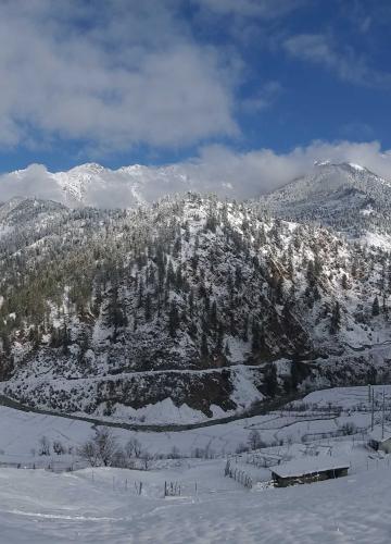
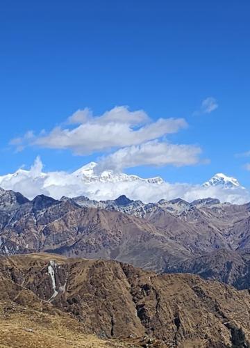
Norbu Kang Peak Climbing is a remote mountain climb in Nepal made for climbers who prefer quiet places, real mountain challenges, and careful planning. The peak is far from busy climbing routes, and only a small number of teams come here each year. This makes it a strong option for people who want a calm Himalayan climb without crowds. The trip includes long trekking days, high camps, and a clear summit plan, instead of fast or commercial-style climbs.

The climb follows an expedition-style setup with a long trek to base camp, slow altitude gain, and planned climbing days. It is best for experienced trekkers and climbers who already know what life is like above 4,000 meters and feel comfortable in tough terrain. The full journey takes time, patience, and strong fitness, but the real value comes from good safety, proper preparation, and a realistic chance of reaching the summit, not from moving fast.

Start planning your Norbu Kang Peak Climbing adventure with clear guidance and expert support from Dolpo Caravan Treks.

Trip Facts – Norbu Kang Peak Climbing

  • Duration: 22 days
  • Maximum Altitude: 6085 m / 19964 ft (summit)
  • Starting Point: Kathmandu, Nepal
  • Ending Point: Kathmandu, Nepal
  • Trekking Distance: Approximately 120–140 km / 75–87 miles total
  • Average Trekking Hours: 5–8 hours per day
  • Difficulty Level: Strenuous / High-altitude mountaineering required
  • Best Seasons: Spring (March–May) and Autumn (September–November)
  • Accommodation: Hotel in Kathmandu, teahouses during trekking, tents at base and high camps
  • Meals Included: Breakfast in Kathmandu, all meals during trek and expedition, farewell dinner
  • Group Size: Small groups for better support and flexibility (usually 4–8 climbers per guide)

Trip Overview

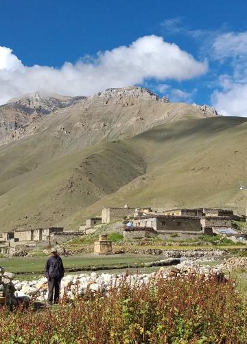
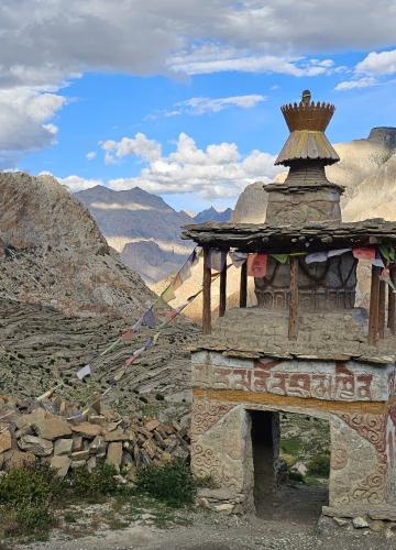
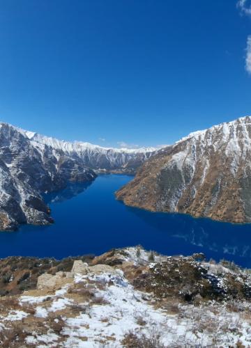
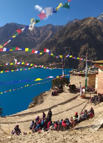
Here we get a clear picture of what the Norbu Kang Peak Climbing experience is like and what climbers can actually expect from the expedition. The climb happens in a high-altitude part of the Himalayas that most tourists haven’t explored.

The trip mixes trekking, getting used to the altitude, and a technical push to the summit into a steady-paced expedition with support from professional logistics. From when you arrive to when you leave, the planning focuses on safety, being efficient, and respecting the mountain.

  • High-altitude peak climbing in a quiet Himalayan area that few people visit
  • A mix of trekking, getting used to the altitude, and a technical summit push
  • Big mountain views, untouched nature, and a strong wilderness feeling
  • Professionally handled logistics from arrival to departure

Why Choose This Norbu Kang Peak Climbing Trip

The trip is planned around the proper time to get used to the altitude and realistic summit goals, not tight schedules. Groups are kept small so it’s easier to talk, adjust plans, and give each person attention on the harder parts. Local guides are really important, especially for picking routes, deciding on the weather, and handling high-altitude areas in remote places.

Every part of the climb is planned openly, with enough time for rest days, practice climbs, and weather delays. This way, it lowers unnecessary risks and makes the trip safer and better overall without taking away from the serious nature of the expedition.

Detail Itinerary

In the morning, you can just wander around Thamel for a bit while we sort out all your trekking papers like TIMS, Climbing Permit and National Park Permit. No need to stress about that part. We handle it. Once everything is ready, you collect the documents from our representative and then head toward the domestic terminal at Kathmandu airport.

From Kathmandu, we catch a domestic flight to Nepalgunj. It is a short but interesting flight. Nepalgunj is a busy town in the western Terai, really close to the Indian border and Bardia Nationl Park. Because of its location, it works like a big gateway for the western, mid western and far western parts of Nepal. You will stay overnight at a hotel or lodge there.

Today we hop on a short flight, around 35 minutes, to Juphal. This is the real starting point for Norbung Kang Peak Climbing in Dolpo. The flight itself feels dramatic, with hills and deep valleys below you. And once you land, it finally starts to feel real.

As soon as we begin walking, the trail climbs southeast, high above the Thulo Bheri Valley. It is a steady uphill, nothing too crazy, but enough to warm you up. After that, we pass through maize fields for about an hour until we reach Kalagaunda village. Simple houses, quiet surroundings, and that slow mountain life vibe.

From there, we follow the southern bank of the Bheri River. The sound of the water stays with you. We pass Roop Ghar, where you can see a traditional water mill still in use, and then continue toward Dunai at 2140m.

Dunai is actually a fairly large mountain town. You will see schools, a health post, government offices, even a police station, plus a few tourist class lodges. It feels lively compared to the smaller villages. We stay overnight in one of the lodges in Dunai, most likely at Pala Guest House.

Today the Expedition to Norbung Kang really starts to feel serious. We leave Dunai behind and walk deeper into the mountains. The landscape here honestly reminds many people of the European Alps. Big open views. Rocky slopes. Fresh mountain air that just hits different.

The trail in this section is rocky and scattered with stones, and you will notice plenty of blue pine trees along the way. After some steady walking, you start catching sight of the snowcapped peak Kang Tokal (6294 m). It suddenly appears in the distance, and it is one of those moments where everyone quietly takes a photo.

Like most trekking days in Nepal, this one comes with its fair share of ups and downs. Nothing flat for too long. The path stretches beside the Thuli Bheri River, so you often hear the water rushing nearby. We pass a few villages along the way. Byasghar, a Magar settlement that follows Tibetan Buddhism, is one of the memorable stops. It is small, peaceful, and worth slowing down for a minute.

After Byasghar, the trail toward Upper Dolpo gets a bit tougher. The path narrows, and the rocky sections demand more attention. You need to watch your steps here. By the end of the day, we finally reach Lingdo. It is a small village with plenty of good camping spots, which makes it a perfect place to rest for the night.

We gain almost 1000 meters in elevation, so yeah, it starts with a steady uphill right away. Not too fast, just a slow grind. As we climb, we keep seeing cliff hanging villages like Sarakot stuck to the hillsides. It almost looks unreal, like someone placed them there by hand.

Further along, we walk clockwise around mani walls and chortens, just the way locals do. You get wide views of Kang Tokal again, plus thick green vegetation all around. The trail is rocky and uneven, scattered with pines and fir trees. We keep moving higher along the Thuli Bheri River. At one point, we cross a long, high suspension bridge over the river. It swings a little, of course. That part always wakes you up. Soon after, we reach Laisicap.

We stop here for lunch. A good break. Then we continue. The next three hours are tough. It is a continuous uphill through pine forest that really tests your legs. After that, there is a short downhill to the riverbed, and then one last push on a leveled trail for a brief stretch. Finally, we reach Laini Odar. We stay overnight in tented camps.

Today is a bit kinder on the legs, but it is longer. So it is not hard, just steady. We start with an uphill climb that takes about forty five minutes and brings us to the top of a small pass. Nothing too dramatic, just enough to get the blood moving.

From there, the trail feels much easier and honestly more relaxed. There are short ups and downs, but nothing too demanding. Most of the walk goes through beautiful pine forest. It is quiet, cool, and peaceful. After around five hours of trekking, we finally reach Nawarpani.

The landscape changes in a big way after Nawarpani. It almost feels like you walked into a different world. The first part still has some greenery, but later the views turn dry and barren. Wide open spaces. Windy trails. Raw mountain beauty. This section also gives you a chance, if you are lucky, to spot blue sheep or even a snow leopard somewhere high on the cliffs.

There is a narrow, tunnel like trail between tall cliffs that climbs steeply for about thirty minutes to a small pass. It is short but sharp. From that pass, another thirty minutes of walking brings us to Sisaul. We stay overnight in tented camps.

After leaving Sisaul, the trail climbs again to another small pass. Once you cross it, the valley suddenly opens up in a dramatic way. It is one of those views where you just stop for a second and look around.

From here, the path becomes more barren, with only a few small bushes scattered around. And as we move closer to Upper Dolpo, even those bushes start to disappear.

The trail to Dho Tarap follows the Tarap Khola. After some time, you begin to see a small settlement in the distance. As we walk closer, we pass many mani walls and small chortens along the way.

When we finally enter Dho village, you can clearly see the ancient Tibetan culture still alive in this remote part of Upper Dolpo. It feels untouched by time. We spend the night in a tented camp in Dho.

After trekking for almost a week, everyone feels it. Legs get heavy. Shoulders feel tight. So today is a rest day at Dho Tarap. But rest does not mean sitting inside the tent all day doing nothing.

We go for short hikes around the area to help with acclimatization before moving higher toward the summit of Norbung Kang Peak 6085m. Your body needs time to adjust to the altitude. Walking slowly around the village actually helps more than just lying down.

Dho Tarap itself is a beautiful highland settlement filled with monasteries. It is quiet, wide, and surrounded by big open valleys. There are many places worth exploring here, so talk with your guide and decide what interests you most. Below are some of the main sites around Dho Tarap.

Ribo Bumpa Monastery

One of the most sacred monasteries in Dolpo, Ribo Bumpa Monastery was built nearly 1000 years ago by Jigme Nyima Gyaltzen and Lama Tenzing Tragye. It was constructed to drive away evil spirits believed to be wandering in the region. The design of the monastery looks similar to the famous Samye Monastery in Tibet.

The word Bumpa means vase, which is one of the sacred Buddhist symbols. You can actually see this sacred vase inside the monastery. Local legends say that if this vase is ever damaged, Phoksundo Lake would burst and sweep away lower Dolpo. People here take that belief very seriously.

Kakar Labrang Monastery

Also known as Kakar Gompa, this white valley temple dates back to the 12th century. It belongs to the old Nyingma pa sect of Buddhism. The monastery was funded by the king of Mustang and construction began under Urgyen Tenzin.

Inside, you can see eight major forms of Guru Rinpoche shown in different moods and expressions. It is a peaceful place, and the history there feels very alive.

Drakmar Dewa Monastery

High on a hill southwest of Dho, Drakmar Monastery sits beautifully against red cliffs. It is about 900 years old. Inside, there are images of Sakyamuni Buddha, Dorje Phurba, and visions of Guru Rinpoche.

There is also a stupa nearby and a book that contains translated teachings of 100 words of Buddha. The location alone makes this monastery worth the hike.

The area around Dho Tarap has even more important monasteries, including Mekhyim Monastery, Dhoro Monastery, and the Bon Gompa of Shipichowk among others.

So take your time and choose wisely which monastery you want to explore. Each one tells its own story.

We start the day with a gentle uphill walk from Dho Tarap. It feels calm at first. After about an hour of climbing, we reach Crystal Mountain School and the Health Post. Seeing a school and health post in Dolpo is actually rare, so it catches your attention right away.

On the way to Numa La Base Camp, we follow an easy trail that takes us to Tokyu at 4209 m. Tokyu looks like a village from another time. Traditional houses, wide open layout, and a beautiful kani gate welcoming you in. On a bright sunny day, this place is a dream for photographers. The light hits the village just right.

Beyond Tokyu, the trail quickly crosses the river toward Kanger. As we walk, if you look to the northwest side of the main trail, you can see dramatic views of Shering Gompa, where monks live and practice. It stands quietly against the landscape.

After this point, the comfortable trail more or less ends. The path turns wild and barren. It becomes more rugged as we climb toward the Base Camp of Numa La at around 4350 m. The final stretch feels remote and raw. We spend the night camping at Numa La Base Camp.

Today is tough. The climb toward Numa La Pass really pushes your endurance. Right from the start, the trail heads up toward what feels like an endless ridge.

The path is rugged and steep, and gaining elevation here is both exciting and exhausting at the same time. You feel strong one minute, then completely drained the next. But then you look up and see Mt. Dhaulagiri and Churen Himal standing tall in the distance, and somehow that gives you a second wind.

The snowcapped peak Norbung Kang also dominates the skyline along the way. It feels closer now. More real. After about four solid hours of steady effort, we finally reach the top of Numa La Pass at 5310 m.

The top is wide and open, with prayer flags fluttering wildly in the wind. It is one of those proud moments. From here, we begin descending. The downhill is much easier compared to the climb.

The trail follows Gyambo Khola, crosses a few spurs, and slowly drops into the wide, beautiful meadow of Danighar at 4512 m. We stay overnight in a camp at Danighar.

The tenth day of Norbung Kang Peak Climbing finally brings us to the Base Camp of this beautiful mountain. After days of trekking through Dolpo, it feels big. You can actually see the mountain up close now, not just in the distance.

Once we reach Norbung Kang Base Camp, we take time to explore the area. Walk around a little. Check the surroundings. Get familiar with the terrain. This is where the real climbing phase starts to feel serious. We stay overnight in a tented camp at base camp.

Before moving higher, it is smart to understand the mountain better and let your body adjust properly. So today is all about staying around Norbung Kang Base Camp and getting used to the altitude.

We take short hikes nearby and gain a bit of elevation during the day. Nothing extreme, just enough to help with acclimatization. Later, we come back down to sleep at Base Camp. That basic mountaineering rule, Climb High Sleep Low, really matters here.

We spend another night in the tented camp at Base Camp.

Another rest day. And yes, it is needed. We stay around the higher camp and spend the day exploring the nearby elevated areas so the body can adjust properly to the altitude.

These short walks are important. You go a little higher, move slowly, and then return to camp. It helps your system adapt without pushing too hard. Drink plenty of water. Eat well. Try to sleep properly. The big climbing day is coming soon, so this is the time to prepare both body and mind.

We stay overnight in the tented camps.

Today is the big one. We wake up early, usually before sunrise, and start moving toward the Summit of Norbung Kang Peak. It feels different from other mornings. Quieter. More focused. We have acclimatized properly over the past days, so climbing a peak just above 6000 m now feels achievable, not overwhelming.

In terms of technical skills, the mountain is not extremely complicated. It does not demand advanced climbing techniques. But basic alpine skills are a must. You need to know rope work, ice work, and how to properly use your mountaineering gear. These basics matter up there. No shortcuts.

Step by step, we make our way up and finally reach the Norbung Kang Peak summit. Standing there is something else. You see massive Himalayan peaks almost at eye level. To the north, the Tibetan landscapes stretch wide and open. To the south, deep valleys roll out below. It is one of those views that stays in your memory.

After spending some time at the top, we begin our descent carefully and trek all the way back down to the Base Camp of Norbung Kang Peak. Long day. Big achievement.

On big adventures like peak climbing and expedition trips, having a reserve day is always a smart move. Mountains do not run on our schedule. Weather can change. Winds can pick up. Sometimes small health issues or unexpected delays happen. So this extra day is there to keep things safe and flexible.

If bad weather affects our summit plan, we use this day to adjust without stress. No rushing. No unnecessary risk. That is the whole idea behind keeping a reserve day in Norbung Kang Peak Climbing.

And if everything goes perfectly according to plan, then great. We simply enjoy a free and relaxed day in Kathmandu at the end of the Norbung Kang Peak Climbing journey.

Today we leave Norbung Kang Base Camp and start heading back the same way we came. It feels different on the return. Lighter somehow. Maybe because the hard part is done.

We retrace the trail carefully and make our way back to Danighar. The path is familiar now, so it feels smoother. By the end of the day, we reach Danighar and stay there overnight.

The trek starts hard today. No warm up. Right away, we climb steeply along a rough yak trail that looks like it has seen years of use. The path toward Baga La Pass gains elevation quickly, and you feel it almost immediately.

We gain around 600 meters in a short stretch, and honestly, this section demands real effort. Breathing gets heavier. Steps get slower. But we keep moving. When we finally reach the top of the pass, we see sacred chortens standing quietly against the sky.

From up there, Norbung Lang Peak rises right in front of us, along with other peaks lining the ridgeline. The view from the pass is easily one of the most beautiful moments of the whole adventure. It feels big. Open. Wild.

Then we start descending. The trail drops into a deep ravine, and we cross a frozen stream before stepping into a more open area. The final stretch brings us down to a wide, beautiful meadow called Yak Kharka at 4000 m. That is where we stop for the night.


Today’s walk takes us through forested sections. It feels calmer compared to the high passes. The trail moves in and out of the woods, with a mix of small ascents and descents along the way.

Nothing too extreme, just steady walking. Up a little. Down a little. Step by step we make our way toward Phoksundo.

Today is all about slowing down and enjoying the area around Ringmo and the stunning Phoksundo Lake. We begin by walking around Ringmo Village and then head toward Tshowa, the lake shore Bon Monastery. The Gompa sits high on a ridge above the lake and was built around 900 years ago.

Exploring this Bon Monastery feels special. It is quiet, spiritual, and full of history. After spending time there, we carefully descend along steep sided cliffs toward Phoksundo Lake.

The lake is famous for its deep turquoise color. It almost looks unreal. The scenery around it is dramatic and wide open. From the lakeside, Ringmo village looks like a classic Tibetan settlement, peaceful and simple. You can also spot beautiful glaciers above and near the lake area.

There are several monasteries and Bon po religious sites inside the park, and we spend time visiting some of them. Along the way, we also explore natural spots and just enjoy being surrounded by this incredible landscape.

We start the day walking along the riverside. At first, the trail is fairly flat and easy. But that does not last long. Soon we begin climbing a steep uphill section that really wakes up the legs. After about an hour of steady climbing, we reach the top of a hill. From there, the river we had been following looks smaller and far below.

From this hilltop, we get one last view of Phoksundo Lake. And honestly, it is stunning. That deep turquoise color stays in your mind. After taking it in, we descend for a while and then continue on a more leveled trail toward Chunuwar.

Beyond Chunuwar, the path gently drops through lush pine and birch forests to Rechi. Then we continue with a series of soft ups and downs along the river. This stretch lasts nearly three hours. As we move closer to Chepka, the landscape begins to change. You start seeing signs of tropical forest, with bamboo and walnut trees appearing along the way.

By the end of the day, we reach Chepka and set up camp for the night.

About an hour of walking from Chepka brings us to Shyanta. Then another hour takes us to Kageni. After Shyanta, the scenery changes in a big way. We leave the forest behind and start walking through more arid landscapes. It feels drier, more open. The rocky views along the way are beautiful in their own rough way, and we eventually reach the checkpost of Shey Phoksundo National Park.

After the checkpost, we cross a metal suspension bridge over Dhim Khola and follow the trail west toward Juphal. Once we cross that bridge, Juphal is roughly three more hours of pleasant walking.

The trail at first is wide and comfortable until we reach Kalagaonda village. Beyond Kalagaonda, the path becomes narrower. It winds through fields of barley and wheat, and you will notice walnut, peach, and apricot trees standing strong around the farms. It feels lively again after so many remote days.

The final stretch is a steep uphill climb to Juphal. It takes effort, but once you reach the large village with its busy marketplace, it feels worth it. We stay overnight at Juphal.

Today we leave Juphal by flight and head back to Nepalgunj. It feels strange after so many days on the trail. From Nepalgunj, we catch another flight to Kathmandu.

Just like that, the expedition to Norbung Kang Peak comes to an end.

Today is departure day. We arrange your transfer to Kathmandu airport for your international flight.

With the final check out completed and support from the Dolpo Caravan Treks staff, the expedition officially comes to a close.

Cost Includes

  • 3-night hotel stay in Kathmandu on a bed-and-breakfast basis
  • Domestic flights between Kathmandu and Nepalgunj (round trip)
  • One expert trek leader with a local assistant for the entire Norbu Kang Peak expedition
  • All meals during trekking and base camp, prepared in local teahouses or camp, including healthy and balanced food, plus tea/coffee and snacks
  • Accommodations throughout the trek and expedition, including teahouses and tents at base/high camp
  • Trekking permits and national park fees for the Norbu Kang Peak region
  • Trekking equipment, including mattresses, member tents, and kitchen utensils for camp
  • Staff salaries, food, insurance, and clothing
  • Farewell dinner in Kathmandu

Cost Excludes

  • Nepal visa fees
  • International flights to and from Nepal
  • Personal expenses and meals in Kathmandu beyond the included services
  • Travel insurance (mandatory for rescue and evacuation during the expedition)
  • Tips or gratuities for guides and support staff
  • Donations and additional local entrance fees not mentioned in the itinerary
  • Extra baggage charges on domestic flights

Useful Information

Cost Breakdown

The cost of the Norbu Kang Peak Climbing expedition varies depending on group size, season, and customization options. As a guideline, the total price typically falls within a mid-to-high range for high-altitude Himalayan climbs, reflecting the remote location, professional support, and safety measures. This range allows flexibility depending on your specific needs, such as private climbing arrangements or extended acclimatization days.

The base cost generally covers:

  • Domestic flights between Kathmandu and Nepalgunj
  • Trekking permits and national park fees
  • Accommodation in Kathmandu, teahouses, and expedition camps
  • All meals during trekking and at base/high camp
  • Experienced trek leader, local assistant, and full support staff
  • Trekking and camp equipment, including tents, mattresses, and kitchen utensils
  • Staff salaries, food, insurance, and clothing
  • Farewell dinner in Kathmandu

Optional costs may include private climbing support, extra rotation or rest days, specialized equipment rentals, or additional sightseeing before or after the expedition.

Factors That Influence the Price

Several elements affect the total cost of the Norbu Kang Peak Climbing expedition:

  • Group size: Smaller groups require proportionally more guides and staff per climber, increasing costs.
  • Duration of the expedition: Longer acclimatization periods or extra trekking days add accommodation, meals, and staff expenses.
  • Level of support: Private guides, specialized climbing staff, or extra porters affect pricing.
  • Season and weather conditions: Peak seasons may have higher costs due to demand for flights, lodges, and permits.
  • Customization: Adding extra acclimatization days, private transportation, or special dietary needs will adjust the cost.

Request a clear cost breakdown from Dolpo Caravan Treks to understand exactly what is included and optional for your climb.

Accommodation & Meals

During the expedition, your accommodation is chosen based on location, altitude, and safety, not just comfort.

On trekking days, you’ll stay in local teahouses or simple camps, depending on the area. When you reach base camp, a fully supported camp will be set up so you can rest and recover properly between climbing rotations. The meals are planned to give you enough energy for the altitude and to keep everything clean and safe throughout the expedition.

Meals During the Expedition

Food during the Norbu Kang Peak Climbing balances nutrition and practicality. A mix of local and simple international meals helps maintain appetite at higher elevations.

Special dietary needs can be arranged with advance notice, allowing the kitchen team to plan safely and effectively.

Difficulty Level & Requirements

This section helps climbers assess whether Norbu Kang Peak Climbing matches their current experience and fitness level.

The expedition is physically demanding, with long trekking days and sustained effort at altitude. Previous high-altitude trekking experience is required, and basic to intermediate mountaineering skills are strongly recommended. Mental endurance is just as important as physical strength, especially during weather delays or extended summit windows.

Best Time to Climb Norbu Kang Peak

Choosing the right season for Norbu Kang Peak Climbing is critical for safety, comfort, and summit success. Weather, snow conditions, and visibility vary greatly throughout the year, so planning your expedition around the optimal months is essential.

Best Season

The ideal periods for climbing Norbu Kang Peak are spring (March to May) and autumn (September to November).

  • Spring (March to May): Temperatures are moderate, snow begins to settle, and the trail opens up after winter. Alpine flowers bloom at lower elevations, making trekking and base camp approaches more pleasant. Summit attempts during this season benefit from longer daylight hours and relatively stable weather.
  • Autumn (September to November): After the monsoon, skies are clear and visibility is excellent. Snow conditions are generally stable, and temperatures are comfortable for climbing. This season provides the best panoramic views of the surrounding peaks and ensures safer trekking and high-altitude climbing conditions.

During these months, logistics are easier, teahouses are open, and support staff availability is high, which makes the expedition smoother and more reliable.

Off-Season

The monsoon season (June to August) and winter (December to February) are considered off-season for Norbu Kang Peak Climbing:

  • Monsoon (June to August): Heavy rain can cause slippery trails, landslides, and river crossings, increasing risks during the trekking phase. Snow at higher altitudes can be unstable, making summit attempts unsafe.
  • Winter (December to February): Extremely cold temperatures, short daylight hours, and heavy snow accumulation make the expedition more challenging. Access to remote regions may be limited, and high-altitude camps require more preparation and winter gear.

While experienced climbers with strong winter skills may attempt the peak during off-season months, the risk level is significantly higher, and additional logistical planning is required.

norbu-kang-expedition.jpg

Tip: Aligning your climb with the best season increases safety, comfort, and the likelihood of reaching the summit. Contact Dolpo Caravan Treks to plan your expedition for the optimal window.

Permits, Safety & Support

Climbing Norbu Kang Peak requires proper permits and organized safety planning due to its remote location and high altitude. Dolpo Caravan Treks ensures all necessary documents, approvals, and safety measures are handled in advance so climbers can focus entirely on the expedition.

Required Permits

All permits are arranged before the expedition and included in the package:

  • Nepal National Park / Conservation Area Permit: Covers entry to the protected area where Norbu Kang Peak is located.
  • Trekking Permit: Required for all trekkers and climbers in the region.
  • Peak Climbing Permit for Norbu Kang Peak: Mandatory for summit attempts, issued by the Nepal government.
  • TIMS (Trekkers’ Information Management System) Card: Required for registration and monitoring of trekkers in remote regions.
  • Local Authority Permit: Some villages or administrative regions require additional permits for entry into restricted or remote zones.

Having these permits arranged beforehand avoids delays and ensures full legal compliance for the expedition.

Safety Measures in Place

Dolpo Caravan Treks prioritizes climber safety at every stage of the expedition. Key measures include:

  • Experienced Staff: Guides trained in high-altitude trekking and mountaineering, assisted by local support teams.
  • Daily Health Checks: Monitoring oxygen levels, pulse, and overall acclimatization to prevent altitude sickness.
  • Weather Monitoring: Continuous assessment of forecasts to determine safe summit windows.
  • Evacuation and Rescue Protocols: Clear plans for emergency evacuation, including helicopter access if necessary.
  • Safety Briefings: Before and during the climb, all climbers are briefed on procedures, route hazards, and decision-making protocols.
  • Technical Support: Fixed ropes, climbing aids, and high-altitude camp management to ensure safe progress during technical sections.

With all permits in place and safety measures enforced, climbers can focus on the ascent with confidence, knowing the expedition is professionally managed and fully supported.

Trekking & Acclimatization Days

The early part of the Norbu Kang Peak Climbing focuses on steady altitude gain and physical adjustment. Walking days are planned to reduce health risks while allowing time to observe how each climber adapts to elevation.

These days also provide time to refresh basic mountaineering skills, organize equipment, and move through remote mountain terrain that sees very little foot traffic. The scenery shifts gradually from valleys to high alpine landscapes, reinforcing the expedition nature of the trip.
If you want help reviewing your fitness level or adjusting acclimatization days, you can contact us for a personalized itinerary discussion.

Summit Push & Climbing Days

Summit days are scheduled with flexibility, allowing decisions to be based on real-time weather and team conditions. Early starts are standard, and turnaround times are clearly defined before the climb begins.

Technical sections may involve fixed ropes and careful movement on snow and ice. Guides maintain clear communication regarding pace, safety, and descent timing. The focus remains on making safe decisions rather than forcing a summit attempt under poor conditions.

Packing List & Climbing Gear

Preparing the right gear is critical for safety, comfort, and performance on Norbu Kang Peak. This list covers personal clothing, technical climbing equipment, and essential documents. All items are recommended for high-altitude conditions, cold temperatures, and remote expedition settings.

Headwear

  • Warm insulated hat or beanie
  • Sun hat or cap for trekking and lower altitudes
  • Balaclava or neck gaiter for wind protection
  • UV-protection sunglasses with high-altitude rating

Clothing

  • Lightweight moisture-wicking base layers (top and bottom)
  • Mid-layer fleece or insulated jacket
  • Down or synthetic insulated jacket for summit and high camp
  • Waterproof and windproof shell jacket and pants
  • Trekking pants and shorts for lower elevations
  • Gloves: light liner gloves and insulated waterproof gloves
  • Thermal socks and spare pairs
  • Comfortable trekking shirts (long and short sleeve)
  • Sleepwear suitable for cold nights in tents

Boots & Footwear

  • High-altitude mountaineering boots (insulated and crampon-compatible)
  • Comfortable trekking shoes for approach and lower-altitude trekking
  • Camp shoes or sandals
  • Gaiters for snow and mud protection

Essentials & Accessories

  • Backpack (35–50 L) for trekking days
  • Daypack for summit push and rotations
  • Sleeping bag rated for -20°C / -4°F
  • Trekking poles for stability on steep or uneven trails
  • Water bottles or hydration system (2–3 L capacity)
  • Headlamp with extra batteries

Personal first-aid kit and medications

  • Sunscreen and lip balm with high SPF
  • Toiletries and personal hygiene items
  • prescribed medicines if any

Technical Climbing Gear

  • Climbing harness and helmet
  • Crampons and ice axe
  • Carabiners, slings, and safety equipment for fixed rope sections
  • Rope for summit push (typically provided by expedition team)
  • Mountaineering boots compatible with crampons
  • Sleeping mat for high camp and base camp

Documents & Miscellaneous

  • Passport and necessary visas
  • Travel insurance covering high-altitude rescue and evacuation
  • Climbing permits and TIMS card (provided by the operator)
  • Copies of emergency contacts and medical information
  • Notebook, pen, and optional camera for documentation

Optional / Recommended Items

  • Energy snacks and protein bars
  • Trekking guidebook or map
  • Lightweight binoculars
  • Personal entertainment or reading material for downtime

Booking Process

This section explains how to move from inquiry to confirmed expedition. The process starts with availability confirmation and discussion of experience level. Customization options are finalized before agreement, followed by advance payment and preparation support.

Early booking helps secure permits, staff, and the best climbing window.

Book Your Norbu Kang Peak Climbing Expedition with Dolpo Caravan Treks

Dolpo Caravan Treks brings proven experience in remote and demanding Himalayan regions, with a strong focus on safety and ethical mountain practices. Every Norbu Kang Peak Climbing expedition is planned with realistic timelines, clear communication, and personalized support before, during, and after the climb.

Reach out with your questions and climbing goals to plan this expedition with confidence and clarity, and contact us today to secure your place on Norbu Kang Peak Climbing.

FAQs

The climb involves snow and ice sections that require basic to intermediate mountaineering skills. Fixed ropes may be used on steeper parts depending on conditions.

You should have previous high-altitude trekking experience and familiarity with crampons, ice axe use, and rope travel.

The full expedition typically takes several weeks, including trekking, acclimatization, summit attempts, and descent.

Group sizes are kept small to ensure safety, flexibility, and effective guide support throughout the climb.

The itinerary includes gradual altitude gain, rest days, and rotation climbs to allow proper adjustment.

Daily health checks, weather monitoring, trained staff, and clear evacuation plans are standard throughout the expedition.

Yes, additional acclimatization days or private climbs can be arranged based on experience and goals.

Safety comes first. If conditions are unsafe, the summit attempt may be delayed or canceled, following agreed turnaround rules.

Review

Leave Your Review

whatsapp